
Frequently Asked Questions
When and Why do I need a Land Survey?
- When buying or selling land to know clearly were the property is on the ground and the amount of land.
- The land is not clearly described in a deed nor marked on the ground.
- To accurately and precisely locate your property.
- To find your boundary lines or corners.
- To create a new parcel parcels of land to sell.
- Before timber is cut near the boundary line.
- To pay property tax on the acreage you actually own.
- To obtain an accurate Legal Description of your property for a new deed.
- To increase the value of the property.
- To determine the location of any Right of Ways or Easements.
- To ensure new improvements such as buildings or fence conform to local zoning ordinances and are on the property.
- To uncover any encroachments, or other potential problems.
- To answer or avoid any current or future dispute or problems.
- Because a deed only contains names of abutting landowners and too vague as to the location of the boundaries and to determine the acreage.
- Because I just inherited the property and would like to know what it consist of.
- Because I want it simple and clear for my inheritance after I am gone.
What is a Land Survey?
A Land Survey is boundary survey of a parcel or parcels of land where measurement are made on the face of the earth and reported in some form often as a Boundary Survey Map. First, comprehensive deed research investigation at the County Registry of Deeds is performed. Deed research of the parcel of land being surveyed, and that of the abutting land owners, often back in time to determine the creation of each pertinent boundary line. Second, field work is performed to locate key physical boundary evidence such as monuments, stonewalls, improvements, roads and areas of occupation, etc. Then calculations are performed on the physical information gathered during the field work. An analysis and comparison is made with the information found during the research investigation and the field work to determine an opinion as to the boundaries.
The results of a Boundary Survey include:
- A Boundary Survey Map, generally 24”x36”, prepared for the purpose of recording in the Registry of Deeds.
- Monuments set at pertinent locations, being previously unmarked corners.
- A written Legal Description describing the property bounds in words.
- Written Report Notes discussing the results of the survey work.
What is Boundary Survey Map?
A Boundary Survey Map is generally a 24" by 36" color map showing the boundary measurements (bearings and distances ) and the monuments found or set at the corners of the parcel surveyed. Also other pertinent information such as abutting landowners names, deed references, physical features such as buildings and driveways, historical record information is shown on the Boundary Survey Map. Also included on a Boundary Survey Map are Report Notes, Title Block, Scale, North Arrow, Location Map, and Symbols or Legend. A Boundary Survey Map can vary greatly in complexity and appearance, depending on the property surveyed and or the client’s specific needs. A Boundary Survey Map is prepared to the standards that would allow for recording at the Registry of Deeds.
What is Monument?
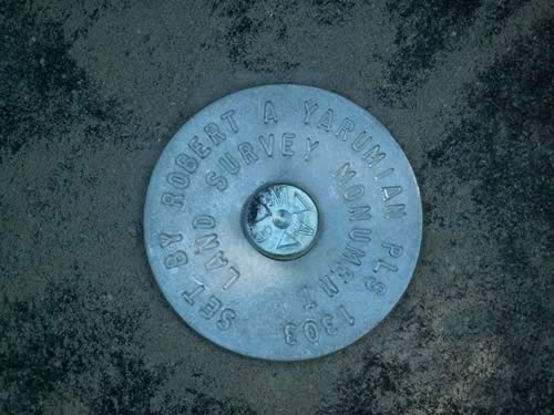
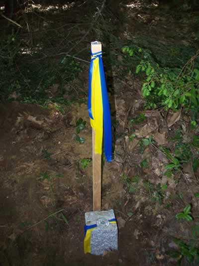
A monument is anything that is deemed to be marking a boundary line or boundary corner. Types of monuments vary greatly and include but are not limited to the following: a stone, a granite post, a tree, an iron pipe, a stump, a water body, a stonewall, a wire fence, and so on. Surveyors today are required to set monuments with their name and registration number on the monument in order to easily determine who placed them. Maine Boundary Consultants generally sets one of three types of monuments:
- Most commonly set is a 5/8" inch diameter rod or rebar with a 2" aluminum cap marked "LAND SURVEY MONUMENT SET BY ROBERT A. YARUMIAN PLS 1303" (View)
- Often times on found stonewalls, found stone monuments, or found trees, we will set a ¼" diameter nail in a drill hole, with a 2" aluminum washer marked "LAND SURVEY MONUMENT SET BY ROBERT A. YARUMIAN PLS 1303". (View)
- Also, on request, we can set 4"x4" (or larger ) cut granite monuments with a ¼" nail and 2" washer set in a drill hole on top. (View)
What is a Legal Description?
A Legal Description is provided as part of the results of a Boundary Survey and describes the subject property words and is also known as a "metes and bounds" description. The "metes" refers to a bearing (direction or course ) and a distance of a particular boundary line and the "bounds" refers to the found or set monument at the corner of the particular boundary line or the monuments on the boundary line such as a stonewall. A Legal Description describes the entire property in this way and is what an attorney will use in order to prepare the actual Deed. The Legal Description will also contain any benefits or burdens of the parcel of land such as easements or right of ways. A statement of the basis of bearing and a reference to a Boundary Survey Map is also included in Legal Descriptions.
What are Report Notes?
Witten Report Notes included on a Boundary Survey Map, usually contains the following: Purpose of the Land Survey, Record Ownership or Deed Reference, Basis of Bearing, Method of measurements, and Plan or past survey References. Also included in the Reports maybe an explanation of the findings, opinion, results and conflicts for each boundary line. This usually contains a statement of the information found in the deeds, and the physical evidence found on the face of the earth. An explanation on how the boundary line or corner was determined for the results of this survey and if needed any potential problems and or conflicts. Report Notes also include a reference or explanation to any benefits or burdens ( right of way, easements ) concerning the property.
View A Sample of Report Notes
Is a Boundary Survey Map necessary?
Unless the client specifically excludes a Boundary Survey Map (plan) from the scope of the surveying services, State rules require that one be prepared. Having a plan of your property provides the client with a permanent record of the survey work performed, as well as the surveyor’s results and findings in the Report Notes. The survey plan will be embossed and signed by the surveyor, indicating that it conforms to State standards and that the surveyor stands ready to defend the results. For this reason, plan is invaluable in the event that a neighboring land owner questions the location of a boundary monument, line, or other conflict. A plan provides the client with a visual representation of the work performed to show the neighbor, and often times how certain lines were determined. The Boundary Survey Map also adds a considerable value and life expectance of the Land Survey.
Can you survey JUST one boundary line?
It is nearly impossible to accurately and reliably survey just one boundary line. In order to correctly determine the location of one boundary line, often two, three, or more other boundary lines need to be surveyed, and often times several parcels away from the boundary line in question. Therefore, if there is a particular concern with just one boundary line, it can be surveyed, but the research and surveying process will involve determining the location of other nearby boundary lines. At times we do only one or a few boundary lines and not a complete Land Survey of the entire property but usually only when there is a great concern on one or a few boundary lines..
I want to put up a fence. Do I need a survey?
Over the years, Maine Boundary Consultants has been asked this question on numerous occasions. Usually the land owner putting up the fence assumes that the cost of a survey will be minimal and that only the line or lines where the fence will be constructed will need to be surveyed. This is generally not the case. In order to accurately determine one boundary line, other lines need to be surveyed as well, and the expense in doing so is often more than the land owner is willing to spend, especially considering the cost of the fence itself. The ideal thing to do would be to meet with your neighbor or neighbors and inform them of your desire to put up a fence and come to some agreement as to where it should be placed. Certainly this is not always possible as perhaps both parties are unsure as to the location of the boundary line, or are in disagreement. If this is the case, then Yes, you may need a survey in order to defend the location of the fence to your neighbor, or future neighbors. It would certainly be a shame to put up a fence on your neighbor’s property and have to remove it and reconstruct it in a proper location.
What is a Sketch Map?
A Sketch Map differs from a Boundary Survey Map in that a Sketch Map is generally shown on 8½" by 11" paper and shows less detail than a Boundary Survey Map. Report Notes is generally not included with a Sketch Map. A Sketch Map may not adhere to the Standards of Practice that a Boundary Survey Map adheres to, and a Sketch Map is not prepared for recording at the Registry of Deeds.
What is a Mortgage Loan Inspection (MLI), and why is it necessary?
A Mortgage Loan Inspection (sometimes called a "Plot Plan" or "Class D Survey") is a land surveyor’s professional estimation of the relative location of the apparent boundary lines of a given parcel of land and the obvious improvements thereon, for mortgage purposes only. Your lender requires title insurance covering certain boundary related problems. In order to provide that insurance, your lender’s title insurance company requires that a MLI be performed. The purpose of the inspection is to detect major boundary problems that would affect the security of your lender’s loan. A MLI also will show any apparent, encroachments, easements or right of ways and will determine if the property is located in a FEMA Flood Hazard Zone.
How else do a Mortgage Loan Inspection and a Boundary Survey differ?
The processes involved and the resultant costs are drastically different. A MLI includes a review of the deed description and its approximate location of the face of the earth. A MLI does not contain the results of any field measurements or new monuments. A MLI is a drawing of a rough sketch of the property based on the information in the deed or perhaps tax map. The MLI is not the results of a Land Survey. A Land Survey is much more involved.